Project Rio Blanco Nuclear Explosion Site
Home / Areas of Practice / Energy Employees Occupational Illness Compensation Program Act (EEOICPA) / EEOICP: Facility List / Project Rio Blanco Nuclear Explosion Site
Also Known As: CONOCO, CER Geonuclear Corp.
State: Colorado
Location: Rifle
Time Period: 1973-1976
Facility Type: Department of Energy
Facility Description
The Rio Blanco site was the location of one of the nuclear tests conducted as part of the AEC’s Plowshare program that was initiated in 1957 to develop peaceful (industrial and scientific) applications for nuclear explosives. The operational period began May 2, 1973. On May 17, 1973, three 33 kiloton yield nuclear devices were detonated in a deep well in a test designed to increase natural gas production from low- permeability sandstone. These explosions, known as the Rio Blanco shot, marked the last nuclear test explosions of the Plowshare program. The operation ended in June 1976. The Rio Blanco site was plugged and abandoned in 1976 and returned to the owner in March 1978.
Listing
Project Rio Blanco Nuclear Explosion Site is listed as a Department of Energy (DOE) site under the EEOICPA.
Compensation
As of 05/10/2015, the total compensation paid under Parts B and E of the EEOICPA, including medical compensation, for workers suffering from the effects of having worked at the Project Rio Blanco Nuclear Explosion Site is $647,174.
Project Rio Blanco Nuclear Explosion Site Workers
If you or your parent worked at this or any other DOE or AWE facility and became ill, you may be entitled to compensation of up to $400K plus medical benefits from the US Department of Labor. Call EEOICPA Counsel Hugh Stephens at 1-855-EEOICPA (336-4272) or fill out the form to the right, even if your claim has been accepted or denied.
We can help with all OWCP (Federal Workers Compensation) claims, impairments, wage loss and health care. 2495 Main Street, Suite 442, Buffalo, NY 14214.
Site Description and History
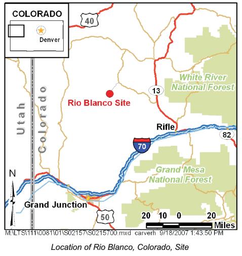
The Rio Blanco Site is located 6,600 feet above sea level in the Piceance Basin in northwestern Colorado, about 52 miles north-northeast of Grand Junction, Colorado.
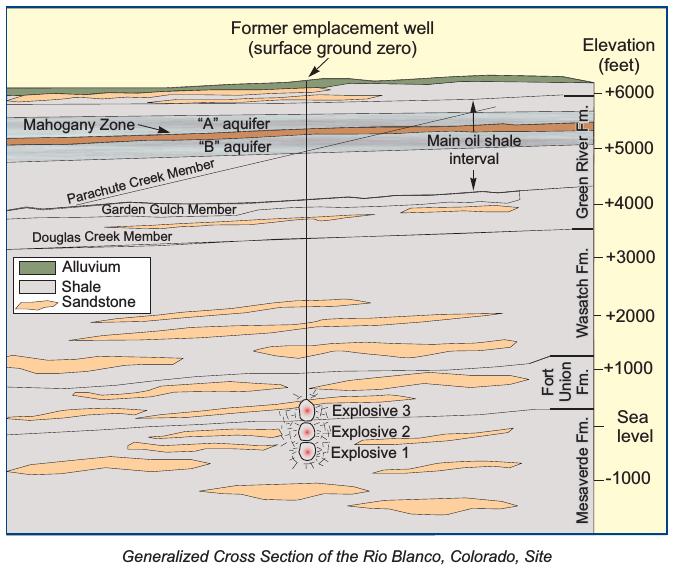
On May 17, 1973, the U.S. Atomic Energy Commission (AEC), predecessor agency of the U.S. Department of Energy (DOE), detonated three 33-kiloton nuclear devices nearly simultaneously in a single emplacement well at depths of 5,838, 6,230, and 6,689 feet below the ground surface at the Rio Blanco Site. The tests were conducted in fine-grain, low-permeability sandstone lenses at the base of the Fort Union Formation and the upper portion of the Mesaverde Formation. This was the third and final natural-gas-reservoir stimulation test in the Plowshare Program, which was designed to develop peaceful uses for nuclear energy. The two previous tests were Project Gasbuggy in New Mexico and Project Rulison in Colorado. The AEC conducted the test in partnership with CER Geonuclear Corporation and Continental Oil Company (Conoco).
The purpose of the Rio Blanco test was to stimulate the flow of natural gas in low-permeability geologic formations. The detonations were designed to create three blast cavities, each with a diameter of about 150 feet. The explosions were expected to create a rubble chimney above each cavity, and the three chimneys were expected to join.
Each downhole explosive package had two major parts: the nuclear device assembly, which was encapsulated in a 30-foot-long canister, and a cooling system, which consisted of one 33-foot-long water tank and three absorber tanks, each about 36 feet long. A tracer gas emplaced with the explosive package would be used to verify that the rubble chimneys were connected. An armored coaxial cable connected all the downhole systems to control equipment on the surface. The detonations initially stimulated gas flow from the upper chimney in above-average quantities, but the pressure dropped 40 percent during post-detonation tests. The natural gas produced was also radioactive. Tracer gases indicated a lack of post-detonation interconnection between the chimneys. The conclusion was that fracturing did not extend outward as far as predicted. Results of subsequent hydraulic fracturing and production tests in a test well installed outside the blast zone were also disappointing. AEC began decommissioning the site in 1975, and surface cleanup and restoration were completed in 1976. One of the test wells was used for injection of contaminated liquid waste from test and decontamination operations. The emplacement well (surface ground zero) and test wells were plugged and decommissioned.

Surface Conditions
Fawn Creek is the only surface water in the site area. The creek flows intermittently but supports common wetland plant species. Fawn Creek is the only wetlands close to the Rio Blanco Site.
A corrective action investigation and risk assessment completed in 2002 at the Rio Blanco Site concluded that no gamma-emitting radionuclides in concentrations above background levels were present in site soil or ground water. Lead and petroleum hydrocarbons were detected in several soil samples collected more than 12 feet below ground surface. The risk assessment indicated that these contaminants do not present a significant risk to human health. The investigation report concluded that no corrective actions were required and that no surface-use restrictions should be placed on the site. The Colorado Department of Public Health and Environment concurred.
A permanent monument consisting of a brass plaque mounted in a concrete base was emplaced at surface ground zero at the site. Wording on the plaque describes the historical significance of the project and restrictions on subsurface excavation.
Subsurface Conditions
No feasible technology exists for removing test-related radioactivity from the subsurface. Because the detonations took place in low-permeability, low-transmissivity shale and claystone formations with sandstone lenses, test-related radionuclides are not expected to travel far from the source area. The only aquifers identified in the area are present in the surficial alluvium and the underlying Green River Formation. The base of the Green River Formation is about 3,000 feet above the depth of the detonations.
Land Use
The principal land uses in the area are livestock grazing and recreation; oil and gas leases exist for the area surrounding the Rio Blanco Site. The Green River Formation, which underlies the surficial alluvium in the region, contains rich layers of oil shale, a potentially valuable resource.
Institutional Controls
The current institutional controls at the site include no subsurface intrusion within a radius of 100 feet from the monument (surface ground zero) to a true vertical depth of 1,500 feet and no subsurface intrusion within a radius of 600 feet from the monument to a true vertical depth between 1,500 feet and 7,500 feet without permission of the U.S. Government.
Long-Term Hydrologic Monitoring Program
Since 1972, the U.S. Environmental Protection Agency (EPA) has annually monitored ground water and surface water at and near the Rio Blanco Site as part of a long-term hydrologic monitoring program. EPA annually samples 15 locations on and around the site, including 4 springs, 4 surface sites, and 5 wells, 3 of which are located near surface ground zero. No radioactive materials attributable to the Rio Blanco test have been detected in water samples.

Share this:
EEOICPA CLAIMS
If you or your parent worked any of the DOE or AWE facilities listed on this website and became ill, you may be entitled to compensation of up to $400K plus medical benefits from the US Department of Labor.
Call EEOICPA Counsel Hugh Stephens at 1-800-548-4494, email hstephens@stephensstephens.com, or fill out the form below whether or not you have already filed a claim and even if your claim has been accepted or denied.
Contact Us
"*" indicates required fields
*note: Submission of this form does not establish an attorney-client privilege.
Contact Us
Address:
2495 Main Street, Suite 442
Buffalo, New York 14214
Phone:
(716) 852-7590
Fax:
(716) 852-7599
After Hours:
(716) 208-3525
Email Us:
R. William Stephens, Esq.
R. Hugh Stephens, Esq.
Lisa P. Neff, Esq.

