Nevada Test Site
Also Known As: Nevada National Security Site
State: Nevada
Location: Mercury
Time Period: 1951-present
Facility Type: Department of Energy
Facility Description
The Nevada Test Site was established in 1951. The mission of the Test Site is to conduct field tests of nuclear devices in connection with the research and development of nuclear weapons. The Nevada Test Site, slightly larger than the State of Rhode Island, has been the primary location for testing nuclear explosive devices since Operation Ranger was first conducted in 1951. In addition, the site is used for low-level waste disposal. Currently, the site is allowing other types of testing at the site, conducting remediation, and is in a standby mode so that if nuclear weapons testing ever is needed again, it could be conducted at the Nevada Test Site.
Throughout the course of its operations, the potential for beryllium exposure existed at this site, due to beryllium use, residual contamination, and decontamination activities.
CONTRACTORS: : National Security Technologies, LLC (NSTec) (July2006-present); Bechtel Nevada (January 1996-June 2006); Reynolds Electrical & Engineering Company (1952-1995). Navarro-Intera, LLC, environmental contractor, (January 2009-present). Wackenhut Service, Inc., provides security related-work, (June 2006-present).
Holmes and Narver was an architectural and engineering contractor at the Nevada Test Site from late 1951 until November 1990. Holmes and Narver’s role at the Nevada Test Site was to design and supervise construction of facilities that included towers, bunkers, instrument stations, tunnel complexes, and other test-support facilities. In November 1990, this function was assumed by a new contractor, Raytheon Services, Nevada.
Listing
Nevada Test Site is listed as a Department of Energy (DOE) site under the EEOICPA.
Special Exposure Cohort (SEC) Classes
Department of Energy (DOE) employees or DOE contractor or subcontractor employees who worked at the Nevada Test Site from January 27, 1951 through December 31, 1962 for a number of work days aggregating at least 250 work days, either solely under this employment or in combination with work days within the parameters (excluding aggregate work day requirements) established for other classes of employees included in the SEC, and who were monitored or should have been monitored.
All employees of the Department of Energy, its predecessor agencies, and its contractors and subcontractors who worked at the Nevada Test Site, from January 1, 1963 through December 31, 1992, for a number of work days aggregating at least 250 work days, occurring either solely under this employment or in combination with work days within the parameters established for one or more other classes of employees in the SEC
Compensation
As of 08/23/2015, the total compensation paid under Parts B and E of the EEOICPA, including medical compensation, for workers suffering from the effects of having worked at the Nevada Test Site is $675,122,868.
Nevada Test Site Workers
Did you, your spouse, or your parent become ill after working at the Nevada Test Site? You may be entitled to up to $400,000 from the United States. For more information, call Attorney Hugh Stephens at (800) 548-4494 whether or not you have already filed a claim and even if your claim has been accepted or denied.
We assist with claims, dose reconstructions, objections, hearings, reopenings, consequential conditions, impairment ratings, wage loss, health care, home care and appeals to Federal Court. No Recovery-No Fee. 2% contingent fee for initial claims/10% for objections. 2495 Main St., Buffalo, NY.
Videos
Color HD footage of atomic bomb tests in Nevada
Published on Jun 11, 2015
High Definition Color footage of atomic bomb tests with active duty military personnel at Camp Desert Rock, Nevada Test Site, Nevada, showing soldiers in foxholes as the nuclear detonation occurs nearby. The soldiers, naturally, were exposed to the nuclear light, shockwaves, and blowing radioactive dust. Soldiers are also seen climbing out of foxholes and running towards the mushroom cloud, causing many soldiers who were present to be exposed to even higher levels of radiation.
DISCLAIMER: This video is part of the Prelinger Archives with the Creative Commons Public Domain Mark 1.0 license. This video is in the Public Domain.
Another film from the Nevada Test Site describing “Project Cue,” aimed at understanding the effects of nuclear blasts on houses and households, can be seen in two parts below:
Part 1 :
Part 2 :
Another view of some of the ways in which NTS Workers were exposed to radiation can be seen in the 1951 film by the Albuquerque Operations Office of Operation Ranger, Operation Buster/Jangle:
Site Location and Background
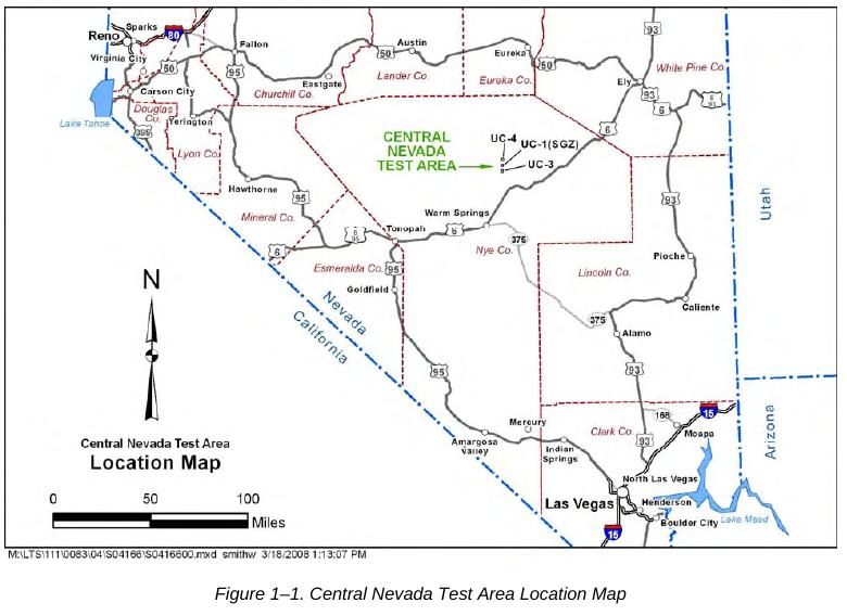
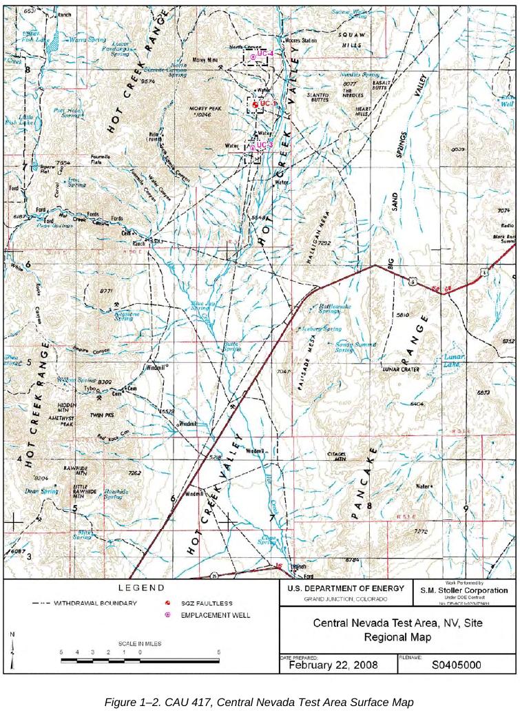
The Central Nevada Test Area (CNTA) is located approximately 22.5 kilometers (km) (14 miles [mi]) north of U.S. Highway 6 and approximately 137 km (85 mi) northeast of Tonopah in Nye County, Nevada (Figure 1−1). Three emplacement boreholes, UC-1, UC-3, and UC-4, were drilled at CNTA for underground nuclear weapons testing. The Project Faultless underground nuclear test was conducted in borehole UC-1 at a depth of 975 m (3,200 ft) below ground surface on January 19, 1968. The other two emplacement boreholes (UC-3 and UC-4) were not used, and no further testing was conducted at CNTA. Boreholes UC-1, UC-3, and UC-4 are located on three separate land withdrawals that range in size from approximately 1 to 1.5 square mi (Figure 1−2). All three land withdrawals are accessible to the public.

Geologic Setting
The CNTA is located in the north-central portion of the Hot Creek Valley within the Basin and Range physiographic province. This province consists of regularly spaced, roughly north-south−trending mountain ranges separated by alluvial valleys formed by faulting. The UC-1 site lies at an elevation of 1,860 m (6,100 ft) above mean sea level and is bordered by the Hot Creek Range to the west and the Pancake Range to the east of UC-1. The Hot Creek Range is composed of Paleozoic sedimentary rocks and Tertiary volcanic rocks. The Paleozoic rocks comprise sandstones, quartzite, limestone, and dolomite, while the Tertiary volcanic rocks comprise welded tuff, nonwelded bedded tuff, argillized and zeolitized tuff, conglomeratic tuffaceous sandstone, carbonaceous siltstone, and rhyolite (Healey 1968). The alluvium at UC-1 is approximately 730 m (2,400 ft) thick and is underlain by tuffaceous sediments and zeolitized tuffs to a depth of approximately 998 m (3,275 ft) (Barnes 1968). The Morey Peak−Hot Creek Caldera is thought to be buried by deposits of tuff and alluvium beneath the northern portion of Hot Creek Valley (Healey 1968).
The Project Faultless test resulted in the subsidence of an irregularly shaped area of approximately 0.9 square kilometer (0.3 square mile). One northeast-trending fault scarp extends beneath the southeastern corner of the UC-1 Mud Pit and cover with as much as 4.6 m (15 ft) vertical displacement. Normal drainage patterns were disrupted by the formation of this scarp, so flood diversion channels were constructed to protect the cover and prevent infiltration along the fault scarp (NNSA/NV 2001). Depth to the water table at the UC-1 CMP is approximately 168 m (550 ft).

DOCUMENTS
NIOSH SEC Petition Evaluation Reports
Petition 55 (Jan 1, 1951 to Dec 31, 1963)
SEC Petition Evaluation Report, Petition SEC-00055, Report Rev # 0
Report Submittal Date: 4-10-2006
Petition 70 (Jan 1, 1942 to Dec 31, 1954)
Merged with Petition 84
Petition 84 (Jan 1, 1942 to Dec 31, 1954)
SEC Petition Evaluation Report, Petition SEC-00084, Report Rev #: 1
Report Submittal Date: January 25, 2010
Technical Basis Documents
Nevada Test Site – Site Description
Effective Date: 05/27/2008
Nevada Test Site – Occupational Medical Dose
Effective Date: 11/26/2012
Nevada Test Site – Occupational Environmental Dose
Effective Date: 08/24/2012
Nevada Test Site – Occupational Internal Dose
Effective Date: 08/17/2012, Revision: 03
Nevada Test Site – Occupational External Dose
Effective Date: 11/09/2012, Revision: 03
Share this:
EEOICPA CLAIMS
If you or your parent worked any of the DOE or AWE facilities listed on this website and became ill, you may be entitled to compensation of up to $400K plus medical benefits from the US Department of Labor.
Call EEOICPA Counsel Hugh Stephens at 1-800-548-4494, email hstephens@stephensstephens.com, or fill out the form below whether or not you have already filed a claim and even if your claim has been accepted or denied.
Contact Us
"*" indicates required fields
*note: Submission of this form does not establish an attorney-client privilege.
Contact Us
Address:
2495 Main Street, Suite 442
Buffalo, New York 14214
Phone:
(716) 852-7590
Fax:
(716) 852-7599
After Hours:
(716) 208-3525
Email Us:
R. William Stephens, Esq.
R. Hugh Stephens, Esq.
Lisa P. Neff, Esq.

